|
|
|
|
|
|
|
|
|
|
The best way to discover the beauty and artistry of the Madaba mosaics is on foot. Madaba today is a bustling market town and the mosaic sites are in a relatively compact area of the city.
The map highlights all major mosaic sites and other points of interest, and suggests a walking routs that takes them all in. Depending on your pace, allow between 1.5 and 2.5 hours for the complete tours. The work of mosaic excavation and conservation is on going, and some sites may therefore not be open to the public from time to time.
Sidewalks may be obstructed in places. Many mosaics are located in churches, which are still in use, so Sunday is generally not the best day to visit Madaba.
The staff of the Madaba Visitors Center, in the heart of the city and close to the major mosaics, are at your service to answer question or provide assistance.
Opening hours: 8:00-14:00 except Fridays. The Government Resthouse next door offers food and refreshments.
|
 |
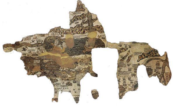
The Madaba Map
This spending mosaic map is housed n the Greek Orthodox Church of St. George, which was built in 1896 over the remains of a Byzantine Church. The map was made to cover the floor of the Byzantine Church, and dates to around 560 AD.
Only part of the map has been preserved it originally measured a staggering 15.7x5.6m,and was made from more than two million stone tesserae. We can but imagine how long it took to construct.
The mosaic shows a clear map of the holy land, extending from the Phoenician cities Type and Sidon in the north to Egypt in the south, and from Mediterranean Sea in the west to the desert in the east. The sites marked on the map, and their captions, are oriented to the east, so they could be read by, people entering the church. Despite the limited space, the mosaics-makers clearly tried to position sites accurately, and many of the features can be easily identified the River Nile, the Jordan River and the Dead Sea (notice how the fish in the river are turning back, swimming away from the salty water!), and the wadis (dry valleys) to the east.
The mosaic-makers used different-sized letters in red, black and white to indicate biblical territories (red) or the relative importance of towns. There, are157 captions, written in Greek, and most of the sites have been identified. They include important cities like Jerusalem, Neapolis (Nablus) and Gaza, as well as towns like kerak and Jericho. Symbols are also used two towers with a gate indicates a town, while a church denotes a holy place. Other symbols include palm trees at Jericho, and the bushes and fords along the Jordan River (notice the ferries at the fords!).
The central focus of the Madaba map is the walled city of Jerusalem, depicted in exquisite detail. Notice first the city walls, with their towers and gats.
The colonnaded main street, or cardo, runs from a plaza with a central column, and two other streets can be seen, together with cites principle buildings. Dominating the city is the church of the Holy Sepulchre, Showing its faط·آ£ط¢آ§ade and the frontal columns of the propylaeum (processional entrance way.
Mariam Hotel
|